

SOUTHERN CALIFORNIA, CA. (Pain In The Pass) >> An early season winter storm is moving toward Southern California on Wednesday morning and last until Thursday. This storm could bring heavy rain showers and thunderstorms at times.
The weather system will slow offshore before turning inland. This will allow several rounds of rain to affect parts of SoCal. The hesvest rain showers will be early Thurday morning.
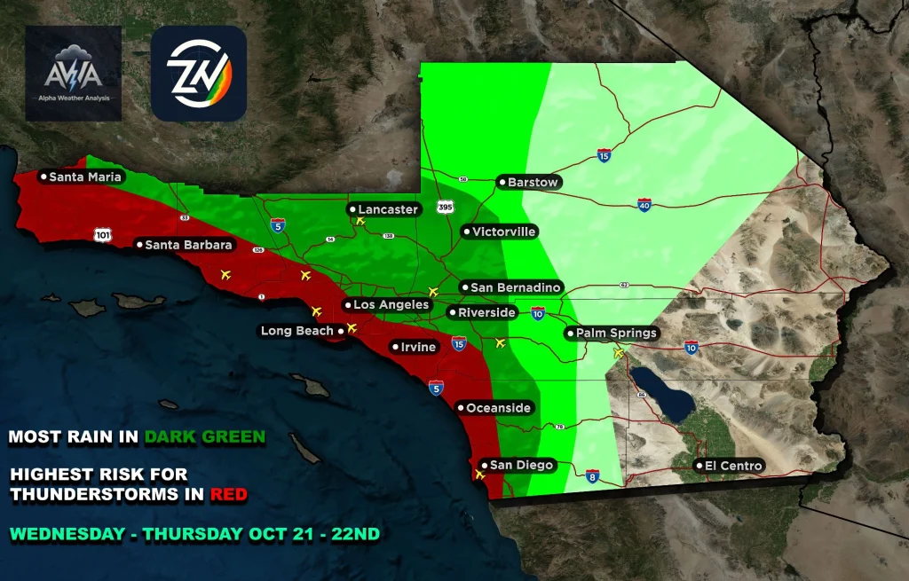
Rain showers will hit the Los Angeles area first around 11am-1pm Wednesday.
Timing for Inland Empire/Cajon Pass. Off and on light to moderate rain showers could start Wednesday afternoon around 4pm into the night. But the bulk of the heavy to moderate rain showers will start late Wednesday night into early Thursday morning around 10pm – 3am. Heavy fog with moderate to heavy rain showers in the Cajon Pass Wednesday evening into Thursday. Rainfall for The Cajon Pass/foothills could get about a ½+ inch to 1+ inch of rain total. The Inland Empire cities could get ½ inch to 1 inch of rain total; each city could vary and if you are near the foothills will get more rainfall. Isolated thunderstorms could bring higher rain totals.
Timing of the storm for the High Desert. Closer to the Cajon Pass will get more rain than Barstow. Rain showers could start around 11pm Wed. – 3am Thursday morning. Light to moderate rain showers for the high desert and it will be off and on rain showers. Chance of isolated thunderstorms could bring higher rain totals. Deserts could get about a trace to ½+ inch of rain total on Thursday. Gusty winds are in the forecast.
Timing of the storm for the Big Bear, Wrightwood area mountains. Off and on light rain showers could start Wednesday afternoon into the night. The bulk of the rain showers could start around 10pm Wednesday night – 3am Thursday morning with moderate to heavy rain showers. The mountains could get about ½ inch to 1+ inch of rain total. Chance of isolated thunderstorms could bring higher rain totals. Gusty winds are in the forecast. Wrightwood will get more rain than the Lake Arrowhead and Big Bear areas.
Runoff will increase quickly under the strongest downpours. Low spots and roads with poor drainage will be especially vulnerable. The heaviest rainfall corridor will be monitored for any changes. Keep in mind strong t-storms will easily bring those numbers higher as well.
If you travel through the Cajon Pass or on Interstate 15 expect traffic due to the weather condition can change quickly. Remember to SLOW DOWN in the rain or in foggy conditions with your headlights on.
One minute no fog then the next minute heavy fog on the freeway.
Please leave early for the commute up or down the pass.
With weather updates from the Southern California Weather Force, Alpha Weather Analysis and the Zone Watch app. They will post updates on the weather, so join both the Facebook, and websites, and app.
There are more ways to follow the Pain In The Pass. Join the Traffic Group on Facebook with over 173,000 members. Join the group on MeWe. Like us on the on Facebook. Follow us on Instagram, and also follow us on Threads, and X aka Twitter.
If you do get into an accident, click or call the trusted professionals of Lerner, Moore, Silva, Cunningham & Rubel Professional Law Corporation.