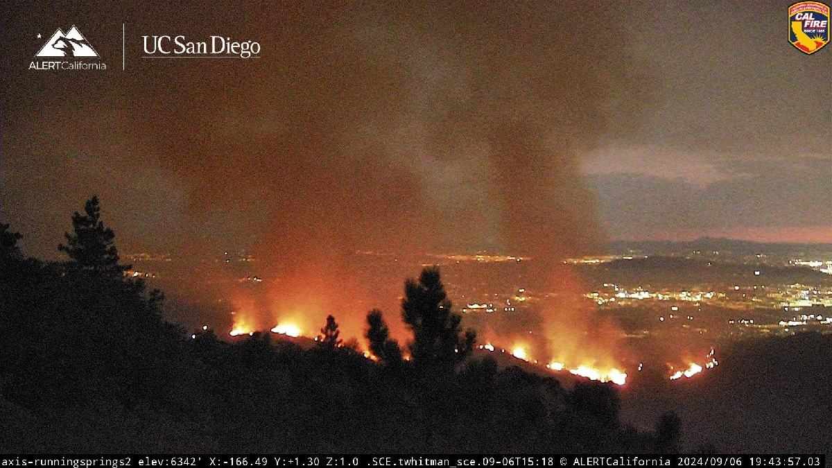
HIGHLAND, CA. (Pain In The Pass) >> The Line Fire, which started in the east portion of the city of Highland in San Bernardino County Thursday evening, exploded to 7,122 acres Saturday afternoon.
The fire, which stood at 0% containment Saturday afternoon, did not threaten or damage any structures or homes at this time.
Evacuation orders:
- Areas from Calle Del Rio to Highway 38, including Greenspot Road north
- All undeveloped land east of Highway 330 to Summertrail Place and north of Highland Avenue
- The areas of Running Spring east of Highway 330 and south of Highway 18
- The communities of Running Springs and Arrowbear Lake
- The area east of Orchard Road to Cloverhill from Highland Avenue north to the foothills
Evacuation warnings:
- Neighborhoods east of Church St, north of Highland Ave.
- Neighborhoods east of Weaver, north of Greenspot to the Iron Bridge.
Air Levels:
Air quality levels near the Line Fire in Highland are approaching unhealthy levels as the blaze sends thick plumes of smoke into the air.
Based on wind pattern forecasts, residents within the high desert could feel the effects of the smoke. Smoke and haze could still be present on Sunday.
If you can smell smoke, you’re breathing smoke. When smoke is present, residents should avoid excessive outdoor exercise or activity. Children, seniors, people with heart or lung disease and physically active adults are at greatest risk during poor air quality events.
If you are impacted by smoke this is what to do:
- Everyone should avoid any vigorous outdoor or indoor exertion.
- People with respiratory or heart disease, older adults, and children should remain indoors.
- Keep windows and doors closed.
- Run your air conditioner if you have one.
- Avoid using a swamp cooler or whole-house fan to prevent bringing additional smoke inside.
Update the grew to over 17,500 acres on Sunday morning and is 0% containment.
Evacuation Order – Level 3 – GO NOW on Sunday Communities of Running Springs and Arrow Bear Lake. Calle Del Rio east to Highway 38 and Greenspot Road north to the foothills. All undeveloped land east of Highway 330 to Summertrail Place and north of Highland Ave. East of Orchard Road to Cloverhill Drive from Highland Ave north to the foothills North of Highland Ave and East of Palm Ave to Highway 330 Garnet Street east to the 38 and Mill Creek north to the foothills Mountain Home Village.
There are more ways to follow the Pain In The Pass. Join the Traffic Group on Facebook with over 145,000 members. Join the group on MeWe. Like us on the NEW page on Facebook. Follow us on NewsBreak, and also follow us on Instagram, Threads, and X aka Twitter.